
Image: IMD Bengaluru
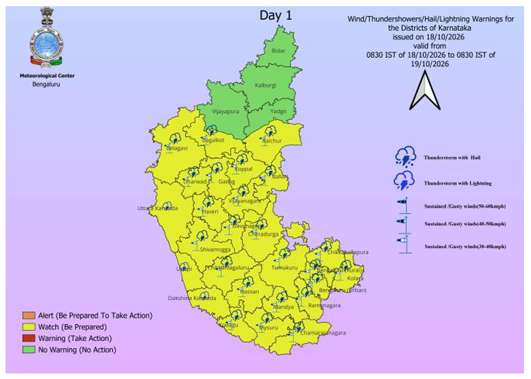
Bengaluru: Bengaluru and large parts of South Interior Karnataka are set for another spell of unsettled weather, with the India Meteorological Department forecasting rain and thundershowers through the next two days and warning of heavy rain accompanied by gusty winds of 30–40 kmph at isolated places.
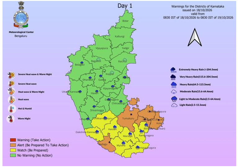
For October 18, IMD has forecast heavy rain with thundershowers and gusty winds at one or two places over Bengaluru Urban, while Bengaluru Rural is among the districts where heavy to very heavy rain is likely at isolated places. Chikkaballapura, Kodagu, Kolar and Tumakuru are also under the heavier rainfall category.
The warning comes after rainfall was already recorded across Bengaluru and adjoining areas. Hesaraghatta in Bengaluru Urban received 5 cm of rain, while Hesaraghatta ARG recorded 3 cm. T.G. Halli and GKVK Bengaluru also reported rainfall during the previous 24 hours.
South Interior Karnataka is expected to remain the wettest part of the state. On October 18, heavy to very heavy rain with thunderstorms and gusty winds is likely at isolated places over Bengaluru Rural, Chikkaballapura, Kodagu, Kolar and Tumakuru. Heavy rain is also forecast at isolated places over Bengaluru Urban, Chamarajanagar, Chikkamagaluru, Hassan, Mandya, Mysuru and Ramanagara.
Light to moderate rain with thunderstorms and gusty winds is likely at most places over Ballari, Chitradurga, Davanagere, Shivamogga and Vijayanagara.
Bengaluru Rain Continues on October 19
The wet spell is expected to continue on October 19.
IMD has forecast light to moderate rain with thundershowers and gusty winds of 30–40 kmph at most places over Bengaluru Urban and Bengaluru Rural, along with Chamarajanagar, Chikkaballapura, Davanagere, Kolar, Mandya, Mysuru, Ramanagara, Shivamogga and Vijayanagara.
Heavy rain is likely at isolated places over Chikkamagaluru, Chitradurga, Hassan, Kodagu and Tumakuru.
The forecast remains active into October 20, when heavy rain with thundershowers and gusty winds is likely at one or two places over both Bengaluru Urban and Bengaluru Rural, besides Chamarajanagar, Mandya, Mysuru and Ramanagara.
Cloudy Bengaluru, 26°C Maximum
For Bengaluru city and its neighbourhood, the IMD local forecast valid until the morning of October 20 calls for a generally cloudy sky with light to moderate rain or thundershowers.
The maximum temperature is likely to remain around 26°C and the minimum around 20°C over the next 24 to 48 hours.
Rainfall observations recorded at 8.30 am on October 18 showed 4.9 mm at Bengaluru HAL Airport, 4.2 mm at Bengaluru City, 4.2 mm at KIAL Airport and 11 mm at GKVK Bengaluru.
Waterlogging, Traffic Disruption Among Possible Impacts
IMD has cautioned that intense spells of rainfall may reduce visibility and cause traffic congestion.
Temporary disruption to traffic due to waterlogging, uprooted trees or broken branches is also possible, potentially increasing travel time.
The weather department has also flagged the possibility of flooding in low-lying areas, damage to vulnerable structures and power disruption if trees are uprooted.
Lightning could pose a risk to people and cattle in open areas.
Residents have been advised to follow traffic advisories, avoid waterlogging-prone areas and river fronts, take shelter during thunderstorms and lightning, and stay away from vulnerable structures.
Rainfall Widespread Over South Interior Karnataka
Rainfall occurred at many places across South Interior Karnataka during the previous 24 hours.
Ramanagara recorded 7 cm, the highest heavy rainfall amount listed in the October 18 daily weather report.
Other notable rainfall amounts included 5 cm each at Hesaraghatta, Hunsur, Krishnarajasagara, Kunigal, Maddur and Chikkanahalli AWS.
The prevailing weather is being influenced by multiple atmospheric systems, including an upper-air cyclonic circulation over the west-central Bay of Bengal adjoining the south Andhra Pradesh and Tamil Nadu coasts, another circulation over North Interior Karnataka and a trough extending across Karnataka.
A low-pressure area has also formed over the Southwest Arabian Sea and is likely to become more marked during the next 24 hours, according to the IMD.
About the Author