Bengaluru Faces Heavy Rain, Gusty Winds on September 20-21 as Karnataka Monsoon Activity Picks Up
Bengaluru: Bengaluru could see a marked increase in rain and thunderstorm activity over the coming days, with the India Meteorological Department forecasting heavy rain at isolated places in Bengaluru Urban and Bengaluru Rural districts on September 20 and 21, accompanied by gusty winds of 30-40 kmph.
The warning comes even as the southwest monsoon remained weak over Karnataka on Thursday morning, with rainfall recorded only at a few places over Coastal Karnataka and at one or two places over Interior Karnataka.
In its Daily Weather Report for Karnataka issued at 12.40 pm on Thursday, the Meteorological Centre, Bengaluru, said thunderstorms are likely at isolated places over Interior Karnataka from September 17 to 21. Heavy rainfall is likely at isolated places over the state on September 20 and 21.
For Bengaluru, the immediate forecast is for generally cloudy conditions with light to moderate rain or thundershowers accompanied by gusty winds reaching 30-40 kmph during the next 24 to 48 hours. Maximum and minimum temperatures are expected to remain around 31°C and 21°C respectively.
The forecast indicates a gradual increase in rain activity for Bengaluru through the weekend.
Light to moderate rain or thundershowers are likely at a few places across Bengaluru Urban and Bengaluru Rural on September 17 and 18.
On September 19, the two districts could continue to receive light to moderate rain or thundershowers at a few places, but gusty winds of 30-40 kmph are also likely.
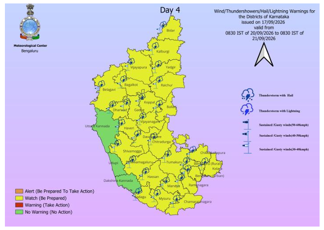
The more significant change is forecast for September 20 and 21, when IMD has placed both Bengaluru Urban and Bengaluru Rural among the South Interior Karnataka districts where heavy rain or thundershowers accompanied by gusty winds of 30-40 kmph are likely at one or two places.
For Bengaluru residents, this does not mean heavy rain is forecast across the entire city on those two days. IMD’s wording specifies heavy rainfall at “one or two places”, indicating isolated heavy spells within the wider Bengaluru Urban and Rural districts. Nevertheless, the forecast signals the possibility of locally intense rainfall and thunderstorms after several days of weaker monsoon conditions.
Rain is expected to become more widespread across Karnataka by September 22 and 23. IMD forecasts light to moderate rainfall at most places across South Interior Karnataka, including Bengaluru Urban and Bengaluru Rural, on both days.
The changing Bengaluru forecast forms part of a broader increase in weather activity expected across Karnataka.
On September 20 and 21, heavy rain is forecast at isolated places across all three meteorological subdivisions of the state.
In Coastal Karnataka, isolated heavy rain is likely over Dakshina Kannada, Udupi and Uttara Kannada districts.
In North Interior Karnataka, Belagavi, Dharwad, Gadag and Haveri could receive isolated heavy rain or thundershowers with gusty winds of 30-40 kmph. Light to moderate rain or thundershowers with similar gusty winds are likely at most places across Bagalkot, Bidar, Kalaburagi, Koppal, Raichur, Vijayapura and Yadgir.
Across South Interior Karnataka, isolated heavy rain or thundershowers with gusty winds of 30-40 kmph are forecast over Tumakuru, Chikkaballapura, Kolar, Ramanagara, Chamarajanagara, Shivamogga, Chikkamagaluru, Hassan, Bengaluru Rural and Bengaluru Urban on September 20 and 21.
Chitradurga, Ballari, Davanagere, Kodagu, Mandya, Mysuru and Vijayanagara are forecast to receive light to moderate rain or thundershowers at most places on the same two days.
Before that, parts of Kodagu, Mysuru, Chamarajanagara and Mandya are forecast to receive isolated heavy rain or thundershowers on September 17.
The latest observations show relatively subdued monsoon conditions. During the period covered by Thursday morning’s observations, Udupi recorded 3 cm of rain, Karwar Observatory 2 cm, Tiptur 2 cm and Sargur 1 cm.
IMD said conditions are becoming favourable for the southwest monsoon to begin withdrawing from parts of West Rajasthan around September 19. This does not, however, indicate an immediate withdrawal from Karnataka.
Several weather systems remain active. A trough extends from North Interior Karnataka to the Gulf of Mannar across South Interior Karnataka and Tamil Nadu, while a cyclonic circulation is positioned over south Coastal Andhra Pradesh and adjoining Rayalaseema.
IMD has also indicated that a cyclonic circulation over north Thailand is likely to emerge over the north Andaman Sea around the evening of September 18. Under its influence, a low-pressure area is likely to form over the region around September 19 evening and subsequently intensify gradually while moving west-northwestwards towards the south Odisha-north Andhra Pradesh coasts over the following three to four days.
For Karnataka, the seven-day forecast therefore points to a transition from the currently weak southwest monsoon conditions to broader rain coverage, with September 20 and 21 emerging as the key days for heavy-rain risk in parts of the state, including Bengaluru.
About the Author